Transmission Facilities Coordination Group
Towers Guide for Wireless Locations
 Montgomery County Code Section 2-58E requires sponsors of wireless communications facilities to submit annually revised antenna site planning information for proposed system construction or enhancement within Montgomery County. The following information is required by the County to assist in planning activities and analysis of co-location opportunities. Applicants must submit a projected growth plan for antenna sites, and must update that plan at least annually. More frequent updates are recommended if information submitted in the previous plan changes significantly. We recognize that site specific information may not be available until late in the implementation process. However, the County desires that information submitted in the plan be as detailed and complete as possible.
- 1. In what geographical areas of Montgomery County will new service be provided or existing service (requiring additional site facilities) be upgraded? (Be specific-such as Route 270 corridor from Shady Grove to the Comus exit, or Along Route 29 form the D.C. line to the Beltway, or at the bottom of the Piney Branch stream valley in Takoma Park, etc.)
- 2. On a large scale map such as the Street Map of Montgomery County, Maryland, prepared by The Maryland-National Capital Park and Planning Commission (scale 1-3000') show the location of existing towers or monopoles, indicate whether each is owned or leased, and show where new antenna sites are anticipated. Locate as accurately as possible, preferably within 0.2 mile or less, or indicate specific sites, if known.
- 3. If specific sites are known, state addresses and how each site is presently utilized, e.g., water tank, apartment building, shopping center, fire station, open (or wooded) lot, etc. If antennas will be placed on an existing tower or monopole on the site, who owns it?
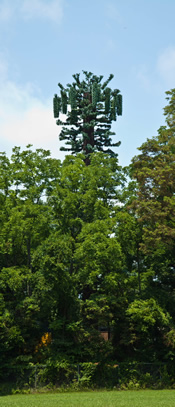
- 4. If any new structures are planned, describe anticipated configuration (monopole, self-support lattice tower, guyed tower, etc.) and height at each site, if known.
- 5. How much physical capacity on each proposed structure will be available for co-location by other service providers? Will antenna space be offered to other parties for rent? If one or more potential tenants have expressed an interest in the site, who are they?
- 6. Any other information relevant to the County tower database.