Monitoring High-Quality Streams
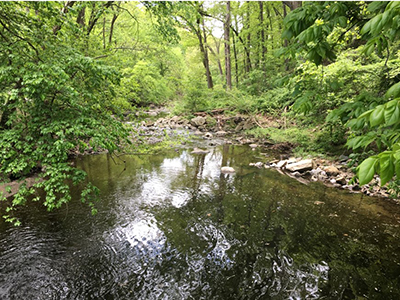
Montgomery County has remarkable Tier II (High-quality) Watersheds known as " outstanding waters" due to their exceptional water quality surpassing federal and state standards. Our team actively monitors these areas using various biological assessments, in alignment with our commitment established under the Clean Water Act of 1972 to protect Montgomery County's natural resources.
Maryland has implemented Tier II regulations, which mandate the protection of these " outstanding waters" beyond minimum federal and state water quality standards. These designations result from thorough biological monitoring and data evaluation, including the Maryland Biological Stream Survey assessments.
To uphold the Clean Water Act's Anti-degradation provisions, any actions within the watershed, such as discharge permits, water/sewer plan adjustments, or development projects, must not harm the current water quality. If negative impacts are unavoidable, specific exemptions must be legally obtained through the Maryland Department of the Environment.
Explore a map of Tier II watersheds in Maryland for more information.
Monitoring Stream Flow for Montgomery County’s Waters
The Montgomery County Department of Environmental Protection (DEP) collaborates closely with the U.S. Geological Survey (USGS) to ensure a comprehensive and continuous assessment of stream flow across various points in Montgomery County, Maryland. These monitoring stations play a vital role in understanding our waterways:
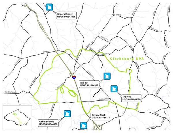
Clarksburg Special Protection Area Stations: Five stations have been operating since 2004, tracking hydrological shifts from changes in land use.
Northwest Branch of the Anacostia River Station: Operating since 1997, this station near Colesville, Maryland, focuses on urban flooding and hydrology related to watershed restoration efforts.
Turkey Branch and Good Hope Tributary Stations: Established in 2007, these two stations analyze stream restoration impacts within the Rock Creek and Anacostia watersheds.
Sligo Creek Station: Since October 2008, this station near Takoma Park has monitored stream flow and will monitor efforts to reduce pollutants in the Anacostia River watershed in the future.
Ten Mile Creek and Clarksburg Stations: Both support the SPA Monitoring Program; these stations evaluate changes related to housing development and stormwater management strategies.
Eastern Montgomery County Stations: Located in Turkey Branch, Sligo Creek, and Paint Branch, these stations monitor stream flow impacts from restoration and stormwater management initiatives.
Southeastern Montgomery County Stations: These three stations track stream flow changes, pollution and support Total Maximum Daily Load (TMDL) monitoring and watershed assessments.
During service visits, technicians from USGS and Montgomery County specialists check data recorders, replace batteries, clear debris, service crest-stage gages, and ensure proper control conditions.
Understanding Stream Flow Data
Stream flow data collection is collected using stream gages. These gages measure water surface height above a known reference point. By combining measurements of stream area and velocity, the volume passing through a specific point over time (discharge) is calculated. This data is crucial for land-use planning, engineering, and assessments. The relationship between water stage and discharge is tracked over time, and the data is available in the USGS Annual Water-Data Report.
Stream flow gages continuously record water surface heights at intervals of 5 to 15 minutes. This data is transmitted nearly in real-time to the USGS Maryland-Delaware-DC Water Science Center.
Locations of USGS Stream Gages
These gages have USGS site identification numbers. You can access real time flow data from these gages using the USGS National Water Information System Web interface
Balancing Aquatic Ecosystems Through Temperature Management
Maintaining the right temperature is vital for aquatic life to thrive. Every species has an optimal temperature range in which they can flourish. While some species might endure higher temperatures, to flourish, water temperatures must stay within their ideal range. For example: brown trout can tolerate temperatures above 68 °F (20 °C), but they are unable to reproduce effectively under those conditions, meaning the species can survive, but not thrive or flourish under those conditions.
In Maryland, we categorize our water bodies into different Use Classes, each carefully defined to support species survival within their specific Class.
Classes of Waters
Class IV Waters
Class IV waters provide an environment where brown trout can survive but not reproduce. These waters serve as fishery areas where periodic stocking helps maintain brown trout populations. Examples include portions of Northwest Branch and Upper Rock Creek. Maryland has established a maximum temperature threshold of 75 °F (24 °C) for Class IV waters.
Class III Waters
Class III waters create a habitat suitable for brown trout reproduction. An instance is Paint Branch in Montgomery County. Here, water temperatures generally stay below 68 °F (20 °C), enabling brown trout to reproduce naturally. With proper regulations in place, like catch-and-release fishing, stocking is not necessary to maintain healthy populations.
Class II Waters
Class II does not apply to Montgomery County streams since it is reserved for brackish water.
Class I Waters
Use Class I waters encompass all other freshwater bodies throughout Maryland with a set maximum temperature of 90 °F (32 °C).
A Closer Look at Temperature Concerns
In most cases, the focus on water temperature centers around preventing it from becoming too high. Temperature spikes often occur due to rainwater runoff from impervious surfaces like roads and parking lots or outdated stormwater management ponds.
Monitoring Stream Temperatures for a Healthier Environment
To strategically monitor stream temperatures, our focus is on addressing high temperatures rather than low ones, during the warmest months of the year, between May 31 and September 30. We install temperature loggers in specific, strategic stream locations in May and retrieve them in October. These instruments are programmed to continuously record the highest temperature within a 24-minute interval during the monitoring period.
Our team at the Department of Environmental Protection (DEP) conducts temperature monitoring at targeted stream sites, especially in areas, like construction zones, where land activities might lead to increased water temperatures. We focus on Special Protection Areas (SPA) by installing temperature meters at specific sites to evaluate the effectiveness of stormwater sediment control devices, erosion control systems (also known as Best Management Practices or BMPs), in minimizing thermal impacts.
Typically, a temperature logger is placed both upstream and downstream of the discharge channel directly in the stream and a developer hires a consultant to monitor the stream's temperature and the water discharged from the BMP. This approach helps ensure that development does not negatively impact the health of our water bodies and the environment.
Tracking Rainfall for Stream Health
Precipitation holds the key to understanding stream flow and hydrological patterns. At the Department of Environmental Protection (DEP), we measure precipitation to accurately capture rainfall and its impact on stream flow. Within the Clarksburg Special Protection Area (SPA), we manage two rain gages, one in Black Hills Regional Park and the other in Little Bennett Regional Park.
Accessing Data
Are you interested in exploring Montgomery County's biological or stream habitat data? You can request access to this information by emailing [email protected].