Watershed Planning
- Restoration Types & Techniques
- Find a Restoration Project
- Watershed Planning
The watershed planning process can be lengthy and includes things like stream monitoring, understanding and analyzing data, using Geographic Information System (GIS) mapping tools, examining watershed impacts such as erosion and impervious (hard) surfaces like rooftops and roadways in order to solve complex problems. The planning process involves many key steps such as:
- Identifying the watershed to assess
- Collecting data
- Data analysis and prioritization
- Drafting the watershed assessment
- Finalizing and publishing the watershed assessment
- Developing an implementation plan
- Hosting and receiving feedback through public meetings at various stages
Using the best science and technology available, staff can utilize tools and data to determine watershed goals, collaborate and share information with the public and various regulatory agencies. Establishing plans that lead to actionable and measurable outcomes that provide benefits beyond clean water is the goal of the watershed planning process.
Watershed Studies/Assessment
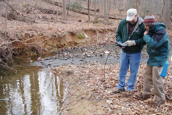
 Staff document stream health concerns and analyze data to develop watershed assessments used to make improvements in water quality.
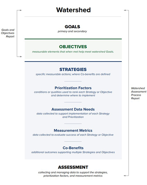
Project Selection
 Project selection is performed after a watershed assessment is completed. Sites are carefully selected, then projects are ground-truthed, designed and constructed.
The project selection process is very involved and includes many facets in order to prioritize projects once a watershed assessment and plan has been completed. From pin-pointing an issue in a watershed assessment to determining a project’s suitability and equity ranking, to establish specific project goals, objectives and co-benefits, each project goes through a rigorous analysis. Each project goes through a series of phases which involves feedback from County residents and various regulatory agencies. Finally, a completed project must also be monitored over time to determine if the long-term goals have been sustained.
Suitability and Equity Mapping Tools
 The County has suitability and equity mapping tools to cross-reference that projects are planned in the most suitable and equitable locations for water quality improvements and our diverse populace.
Clean Water Montgomery and the watershed restoration division’s primary goal is to improve the County’s stream health and water quality for all communities. With a county as diverse as Montgomery, strong partnerships are required to make this happen. By fostering these partnerships and creating new ones, the division can evaluate our planning, design and construction processes to address innovation and equity.
Goals, Assessment, and Data
Program Goals
Satisfying regulatory requirements ( MS4) such as required pollution reductions ( TMDLs)
- Protecting existing stream restoration projects
- Assessing equity in project selection
- Striving to make communities more livable
Assessing Suitability
DEP utilized a suitability modeling exercise to prioritize areas where pursuing restoration projects best align with the Department’s goals. This involved a high-level spatial analysis of the County and multiple data layers to determine areas with the highest suitability for restoration and locations where the department may pursue projects.
Data Analysis
Data analysis included factors such as stream habitat and biological conditions, presence of existing stormwater management, and pollution reduction requirements among many other layers of data. Through the analysis, factors were ranked, weighted, and normalized. The suitability "scores" for the specific maps were developed based on this ranking process.
Two maps-- stormwater management suitability and stream restoration suitability--were created at the completion of the modeling exercise and are designed to guide the department’s restoration efforts by aligning them with the program goals. This also provides the public the ability to transparently see where restoration efforts are being focused.
A third map-- equity assessment--was created to ensure equity is factored during the project selection process and throughout implementation. This map was not a part of the watershed suitability data analysis but gives the department the ability to cross reference area suitability scores with demographic index scores and ensure project selection is not biased.
The suitability models will be used as a basis to pursue more detailed site level analysis and future planning evaluation. The maps also represent opportunities for coordinated partnerships with others to meet complementary restoration goals.
Maps
Stormwater Management Suitability Map
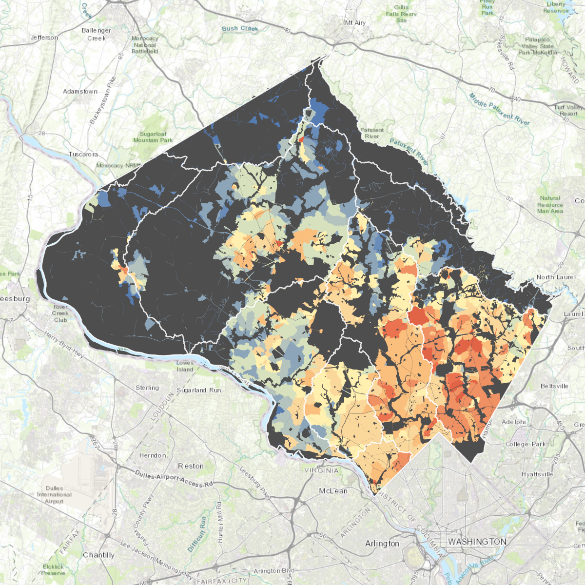 The stormwater management suitability map prioritizes areas that have little/no existing stormwater management, poor stream conditions, high amounts of impervious surfaces, flow to existing stream restoration projects, and require significant TMDL pollutant reductions. Spatial data is weighted, combined, and the resulting map prioritizes areas where DEP can focus on installing upland stormwater management. A ranking was established and suitability scores were split into categories based on the distribution of low (32-73), medium (74-99) and high (100-130).
Stormwater Management Suitability Map >>
Stream Restoration Suitability Map
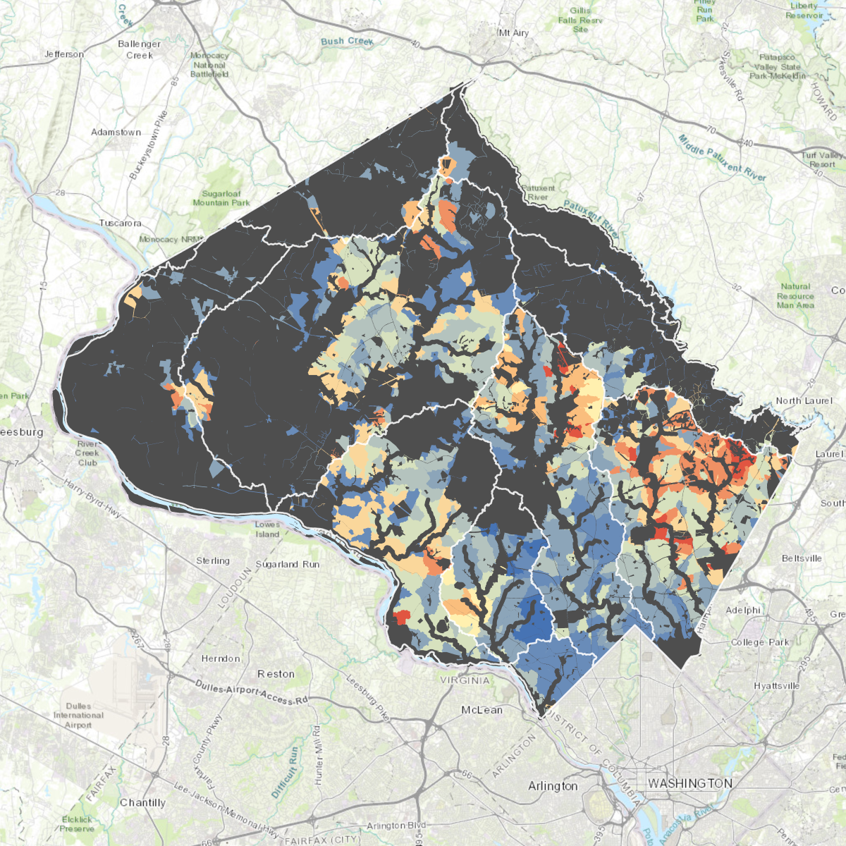 The stream restoration suitability map prioritizes areas where selecting a stream restoration project would have a higher likelihood of improving biology and ecosystem function, significant levels of TMDL pollutant reductions and has less areas of unmanaged stormwater to maximize long term success and stream stability. This map prioritizes the most suitable areas for the County to pursue stream restoration projects and strives to set realistic achievable goals in very distressed watersheds. A ranking was established and suitability scores were split into categories based on their distribution of low (7-17), medium (18-20) and high (21-23).
Stream Restoration Suitability Map >>
Equity Assesment Map
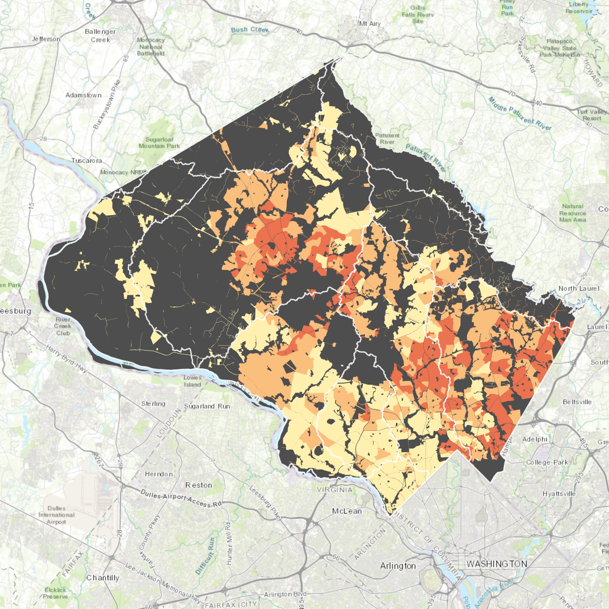 The equity assessment map is a means for the department to ensure equity is factored during the project selection process and throughout implementation. This map utilizes American Community Survey data from the 2019 version of the US EPA EJSCREEN* for census block groups in the County. By utilizing this data and determining the demographic index percentile of an area, the department can assess equity during the project selection process. For example: Data for a census block group located in the Sligo creek watershed indicates the population in that block group is 54% people of color and 12% low income. Averaging these percentages results in a demographic index of 33%. This percentage is then compared to all the census block groups that exist within Montgomery County. Doing so, places this census block group in the 52nd percentile of the County. This equity assessment is split into 3 categories: low (0-33%), medium (34-66%) and high (67-100%). This provides the ability to cross reference percentiles with project suitability to ensure project targeting is not biased.
* For the purposes of this mapping, the term people of color is used to better reflect and depict the diversity exhibited across Montgomery County rather than the term "minority" which is used in the US EPA EJSCREEN
MS4 Permit Program
Reports, Plans & Legislation
- FY25 MS4 Annual Report (PDF)
- FY25 MS4 Annual Report Cover Letter (PDF)
- FY24 MS4 Geodatabase (ZIP)
- FY24 MS4 Supplemental Geodatabase (ZIP)
- FY24 MS4 TMDL Implementation Plan (ZIP)
- Salt Management Plan 2024 (PDF)
- Good Housekeeping Plan 2024 (ZIP)
- Resolution 20-742: Financial Assurance Plan
For most urban areas like Montgomery County, what goes into our storm drains (stormwater) eventually ends up in our local streams. These streams are part of larger systems that flow into major rivers like the Potomac River and, ultimately, the Chesapeake Bay. Since water doesn't recognize county or state boundaries, the federal government takes charge of regulating everything that enters storm drain systems.
To carry out this regulation, the federal government entrusts the state of Maryland through the Maryland Department of the Environment (MDE) with the authority to manage stormwater leading to our storm drains and streams. They do this through a program called the Municipal Separate Storm Sewer System Permit Program, or MS4 Permit Program for short, which they issue to municipalities.
The main objective of the MS4 Permit Program is to reduce stormwater pollution across the United States and preserve the health of our waters. Montgomery County receives its own MS4 Permit from MDE, which requires the County to meet specific water quality standards. This permit is renewed every five years.
Montgomery County's MS4 Permit authorizes them to prohibit pollutants from entering stormwater and to prevent unauthorized discharges. They must also work on restoring streams with poor water quality by achieving required pollutant reduction and implementing other actions to safeguard water quality. The county uses stormwater best management practices to capture, slow down, and treat runoff effectively.
To ensure compliance with the MS4 Permit, the Department of Environmental Protection is leading a collaborative effort involving multiple departments and agencies. Together, they strive to meet the requirements and protect the health of our local waterways and beyond.
Stormwater Management Data for Sediment Control Permits
The Maryland Department of the Environment (MDE) requires Montgomery County to document information for each stormwater best management practice (BMP) for the County’s Municipal Separate Storm Sewer System (MS4) Permit.
As such, Effective July 1, 2024, Montgomery County will collect stormwater management (SWM) data for each new sediment control permit that requires stormwater management in order to meet MDE requirements and for SWM BMP tracking purposes.
Learn how to submit stormwater management data for sediment control permits >>