
FEMA Issued Preliminary Flood Map
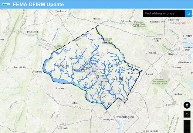
FEMA Preliminary Flood Map
🆕 Federal Emergency Management Agency (FEMA) Region 3 and the Maryland Department of the Environment have provided an update for the ongoing FEMA Risk Mapping Assessment and Planning (MAP) study for Montgomery County, Maryland and incorporated areas. The 90-day appeal period has closed. See the Appeals section below for more information.
FEMA has issued new preliminary Flood Insurance Rate Maps (FIRMs) and a Flood Insurance Study of Montgomery County. These preliminary maps reflect the flood risk based on the latest high-quality data and have been released for public review and comment.
Montgomery County and the cities of Gaithersburg and Rockville participate in FEMA’s National Flood Insurance Program (NFIP) so that residents are eligible to purchase flood insurance as financial protection against flood losses. Jurisdictions must adopt FIRMs to participate in the NFIP.
Frequently Asked Questions
A Flood Insurance Rate Map (FIRM) is an official map of a community on which FEMA has delineated a floodplain, also known as the Special Flood Hazard Area (SFHA). SFHAs are areas identified by FEMA as having a high risk (1% or more) of flooding in any given year. If you have a federally-backed mortgage and your house is in a SFHA, federal law requires that you have flood insurance.
Flood hazards change over time. Updated flood maps provide a more accurate picture of a property’s flood risk.
How water flows and drains can change due to new construction and community development or natural forces such as changing weather patterns or terrain changes. To better reflect your current flood risk, the NFIP and the FEMA use the latest technology and data to periodically update flood maps nationwide.
Everyone lives in an area with some flood risk – it’s just a question of whether you live in a high-risk, low-risk, or moderate-risk flood area. Flood zones are indicated on the interactive map shown in the overview. Each flood zone shows the proximity of a Special Flood Hazard Area (SFHA) to a structure. The proximity to the SFHA is one factor that determines the overall risk of a property and is used to determine insurance requirements and costs. For more information on pricing, visit FEMA’s NFIP’s Pricing Approach.
Consider purchasing flood insurance. If you have a mortgage from a federally regulated lender and you have structures within a Special Flood Hazard Area (SFHA), then by federal law your lender must require flood insurance. Individual lenders may also require flood insurance as a condition of lending their money for structures that are near a SFHA but do not meet the federal flood insurance requirement. For more information on flood insurance, visit the National Flood Insurance Program.
The FEMA Homeowners Guide to Retrofitting outlines ways to protect your home from flooding. Common practices include floodproofing windows, doors, and basements, elevating electrical systems and appliances, and installing water barrier systems.
Reducing your flood risk not only protects your property against flood damage but can also help lower insurance costs.
Please visit the Montgomery County Department of Permitting Services website for more information on building in a floodplain.
Appeals & Comments
The appeal period for FEMA's Preliminary Flood Model has closed. The appeal period opened on Jan. 17, 2025 and closed on April 17, 2025. This appeal period provided property owners the opportunity to review and provide feedback on the preliminary flood hazard maps. We have not been provided a timline for the review of these appeals; however, given that several of the submitted appeals include detailed engineered hydraulic and hydrological models as part of their appeal, resolution of these appeals is not expected until this summer.
- Appeals address concerns that the modeling or data used to create the map is technically or scientifically incorrect and must be accompanied by technical documentation, such as information provided on the FEMA Preliminary Map information, surveys, topographic maps, engineering studies, data, etc. Appeals should also demonstrate that better methodologies, assumptions, or data exist.
- Comments address a perceived map error such as an incorrect street name, city limit boundary, etc. A detailed description of the issue should be submitted. Supporting documentation may not be required.
Following the resolution of the appeals and comments, FEMA will notify communities of the final maps and effective dates.
Meetings and Outreach
Montgomery County, the City of Gaithersburg, and the City of Rockville provided three information sessions for property owners and residents affected by the proposed map changes.
Virtual information session:
In-person information sessions were held:
Saturday, Feb. 10, 2024
Thursday, Feb. 15, 2024
Hosted by the City of Gaithersburg.
Contacts
William Musico, PE
[email protected]
Floodplain Administrator / Water Resources Plan Review
Montgomery County Department of Permitting Services
2425 Reedie Drive, 7th Floor
Wheaton, Maryland 20902
240-777-6340
Meredith Neely, PE
[email protected]
Principal Environmental Engineer
Environmental Management Division
City of Rockville, Public Works Department
111 Maryland Avenue, Rockville, MD 20850
240-314-8874
Nancy Schumm, PWS, CMSM, MPESC, CESSWI
[email protected]
Environmental Services Division Chief
City of Gaithersburg Public Works
800 Rabbitt Road, Gaithersburg, MD 20878
240-805-1327