
DPS GIS Maps
Floodplain and Storm Drain
The DPS floodplain map shows floodplains and other relevant drainage-related information over a Geographic Information System (GIS) map. The goal of this map is to provide engineers, planners, and property owners with useful information regarding floodplains and drainage. The map collates federal and local floodplain maps in a single resource to enhance public awareness and understanding of flood-prone areas, potential flood risks, and associated hazards within a specific region.

My Inspector and Property
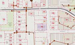
The My Inspector and Property Map provides DPS customers information about upcoming inspections, property details, and contact information for the inspector. Additionally, the GIS map allows stakeholders to find recent permit applications near their home or within a bounding box. The GIS Inspector and Property map is designed to improve transparency and construction awareness near your home or property.
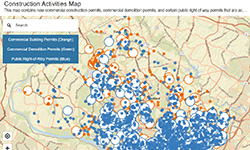
Neighborhood Construction Activities Map
The map below shows construction activity in Montgomery County. Permits included are active Commercial Building, Commercial Demolition and Public Right of Way. Map data is updated daily. All three permit types are shown by default. You may remove a permit type by clicking on the permit name found in the upper left corner of the map.

Use and Occupancy
The Use and Occupancy research map allows stakeholders to find a commercial Use and Occupancy (U & O) certificate by a parcel. This is useful if you are opening a business or changing the use type of a business. The most recent issued U & O for a building, floor or suite is the current U & O certificate. The Use and Occupancy Research Map contains data going back to 1999. Searches for U & O certificates issued before 1999 must be made to DPS via MC 311.